Galbamaanup (Lake Claremont)
Split level, early settlers, John Butler, Dark Water, Swanbourne camp, swamp, Boorloo, vaults.
Galbamaanup House is located adjacent to the open space reserve, Lake Claremont (The Noongar name for the place being: Galbammaanup which means, ‘Place of Black Water’) within the wetland area of Claremont/Swanbourne. The area has a fascinating history with the Noongar myth stating that the wetland was created by the Waugal. Galbamaanup House sits within a 1980’s small lot subdivision and this new house delivered all the client asked for and more on this 220 square metre site.
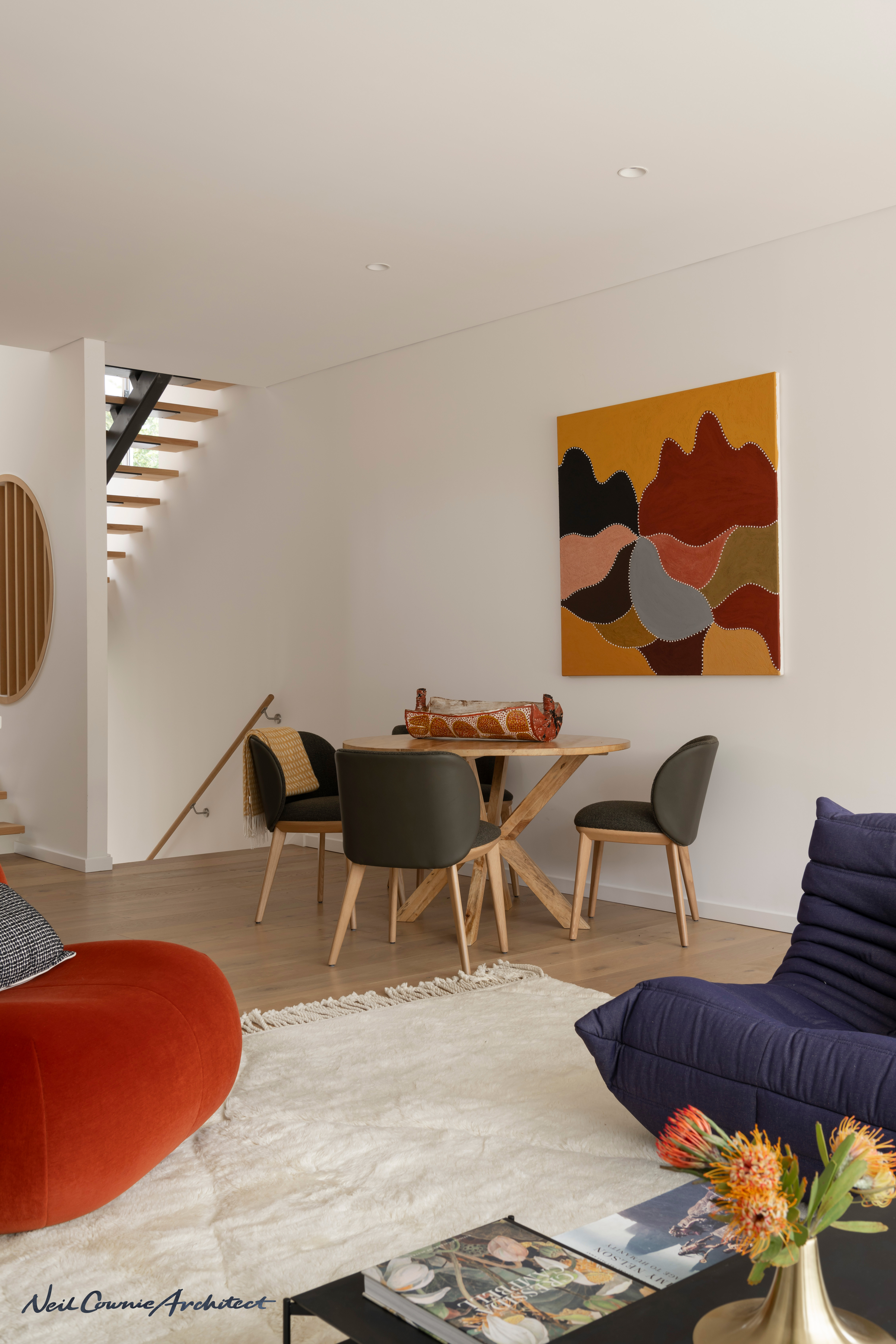
The design service provided by Neil Cownie was holistic in the provision of the architectural design & documentation, interior design, along with coordination of the landscaping.
CLIENT BRIEF
Prior to engaging Neil, clients, Jen & Gavin had already explored some planning solutions for the project. Their brief was to accommodate a bedroom for themselves with ensuite and robe and another two bedrooms with a bathroom for children. Apart from the main living area, a second living area was required along with outdoor areas and possibly a roof terrace.
Jen who can achieve almost anything that she puts her mind to, spent a lot of time in her youth at the ‘Red Parrot’ night club (as did Neil), a fact that seemed befitting the arches of the 1980’s neighbouring houses, and an influence on the buildings form.
HISTORY OF PLACE AND PEOPLE
The site of Galbamaanup House sits within the former wetlands of what is now known as Lake Claremont. As part of the complex wetland systems of the Swan River and swan coastal plains, Lake Claremont (known by Noongar people as Galbamaanup and early European settlers as Butlers Lake) has had history.
Lake Claremont is a seasonal lake, a unique biodiversity ‘hotspot” that is host to a wide variety of flora and fauna. It is a Conservation Category Wetland and a designated Bush Forever site. The area covers approximately 70 hectares.
According to Noongar tradition, the wetland was created by the Wagual and continues to be of cultural significance to Noongar people. The area around Galbamaanup (Lake Claremont) was originally used for camping and hunting. Lake Claremont was a freshwater swamp that had shellfish, tortoises, frogs and reed rhizomes for damper and other bush food like Zamia nuts as well as paperbark resources to build shelters. Noongar families continued to camp at locations around the wetland until the government moved them on in 1951.
Nineteen Pensioner Guards on board the ‘Scindian’, the first convict ship to arrive in WA in 1850, were provided with two lots of land – half an acre of land along the river and nine and a half acres around Galbamaanup (then known as Butlers Swamp). The government provided a ten Pounds cash grant for tools and seeds which had to be mostly spent on provisions. The terms under which the land was granted was that they were required to occupy the land for seven years before the land was then granted for life. (Source” Claremont Museum ‘Lake Claremont Historic Site’).
Only a few of the original pensioners remained on their land and development was slow until the completion of the Perth Guildford Railway line in 1881. A station was constructed on the west side of Stirling Road and Butlers Swamp became a popular picnic spot.
Around the turn of the century, orchards and market gardens began to flourish around the swamp and its popularity as a picnic spot began to wane. Rising waters destroyed much of the market gardens, rendered Stirling Road impassable and profoundly changed the character of the vegetation. The paper bark trees, unable to withstand the permanent submergence, died off. Refer to the image provided of the 1939 flood and the extent of water in the wetlands that extended north of Alfred Road.
It was not until 1949 when further moves were made to turn the swamp into a beauty spot. Naturalists wrote to the paper describing the variety of bird life and urging that the swamp be cleaned and beautified. After considerable discussion and many suggestions, a plan was agreed to in 1954. Included in the plan was provision for an Olympic pool, football, soft ball, a pavilion, boats for hire, tearooms, amphitheatre and large areas reserved for picnic grounds and natural bush. It soon became apparent that the plan was to be very costly to implement and the Council modified the original proposal.
A drive-in cinema was built in lieu of the amphitheatre, the rent from this commercial development meeting loan repayments. Council also exchanged 3.5 acres of land belonging to Scotch College for 4.5 acres which was partly under water. This land was subsequently reclaimed by the College reducing the area of the Lake.
Between 1964 and 1970 the area was used as a rubbish tip; the rubbish being used to fill in the marshy areas around the water’s edge. An island bird sanctuary was built and planted with exotic trees and shrubs. The council then proceeded to construct the golf course, despite objections that it would result in restricted access to the lake foreshore and surrounding areas and objections that it would result in a serious impact on the habitat. In 1955 the Council, in the face of strong opposition from the Royal W.A. Historical Society, initiated steps which resulted in the swamp being renamed Lake Claremont.
Friends of Lake Claremont was established in 2003 to assist in the conservation and enhancement of the lake. Volunteers meet every month to help care for the lake and its surroundings. Neil is a member and advocate of the Friends of Lake Claremont (FOLC). From the FOLC history of FOLC website statement: ‘The first wetland restoration initiatives began in 1987 when Ian Lantzke, P.W. Gabriel and Bruce Haynes conducted the Lake Claremont Environmental Study on behalf of the Town of Claremont. The Lake Claremont Management Plan was published the following year (by Lantzke and Haynes) and used in the 1988 Lake Claremont Implementation Grant ($164,000) to commence rehabilitation of the wetland. The Bird Observation Platform, Stirling Road playground and interpretive signage were installed as part of this program.
The Town of Claremont established the Lake Claremont Management Committee (1992) with Bruce Haynes as Chair. A group of local volunteers began meeting monthly to assist the Town implement its Management Plan, which consisted mainly of weed control and replanting on the western side of the lake. They were assisted on occasion by classes from Scotch College and Graylands Primary School. Progress was slow in the 1990s but elimination of cornflag and lupins as the dominant weeds were markers of some success. Algal blooms and attendant duck deaths, together with tortoise roadkill, were seasonal reminders of the need to continue the work.
In 2003 the Friends of Lake Claremont was established as a community volunteer organisation to assist in the conservation and enhancement of Lake Claremont. In 2009 the group was formally incorporated as a not-for-profit company limited by guarantee in order to access grant funding from State and Federal governments. FOLC enjoys a close working relationship with the TOC and the enhancement of Lake Claremont has broad community support. FOLC are a very active group of local residents and volunteers.’
In 2009 the golf course was closed after a referendum was put to residents concerning the future of the lake. TOC adopted a management plan to return the area to a mix of native bush and recreational areas. A significant wetland restoration and native plant revegetation program is currently underway.
LANDSCAPE AND GEOLOGY
Lake Claremont is a seasonal lake, a unique biodiversity ‘hotspot” that is host to a wide variety of flora and fauna. It is a Conservation Category Wetland and a designated Bush Forever site. The area covers approximately 70 hectares.
Lake Claremont lies in a depression in the Spearwood System of coastal sand dunes. It is a true swamp geographically, that is, it is the above ground part of the massive underground water system common to most parts of the Perth coastal plain (Morris and Knott, 1979,145). This subsoil water flows continuously towards the river and ocean in a northeast to southwest direction.
The swamp lies in a valley between coastal dunes where the ground rises rapidly from 1.5 metres to 12 metres. Immediately prior to 1950, the swamp at high water mark enclosed an area of approximately 20 hectares. During the 1950s and 1960s areas were reclaimed and this reduced the area of the open water to approximately 15.7 hectares at high water mark (Emory, 1975). At the northeast and southern end of the swamp are two valleys and it has been hypothesised that these valleys may have been scoured out by river action (Evans and Sherlock, 1950, 152). Apart from these two openings, the area consists of coastal sand dunes of aeolian origin, partly consolidated by low shrub vegetation and intermittent wattle (Evans and Sherlock, 1950).
ARCHITECTURE AND DESIGN
Through research about the history of the place we became aware that Lake Claremont had been known by Noongar people as ‘Galbamaanup’ which means ‘place of dark water’. Neil’s clients, Jen & Gavin shared the interest in this Noongar history of the place and together resolved to reinforce the use of this naming of the area by naming the house after Galbamaanup. This agreement in the naming of the house was soon after part of a more public push to the Town of Claremont for dual naming recognition of the place which we provided our full support to the cause through Friends of lake Claremont.
The site of the now Galbamaanup House forms part of what looks like to have been an early 1980’s subdivision and the road, ‘Links Court’ was constructed to serve the sub-division. The small single story 1980’s house on the 220sqm site was demolished to make way for this new house.
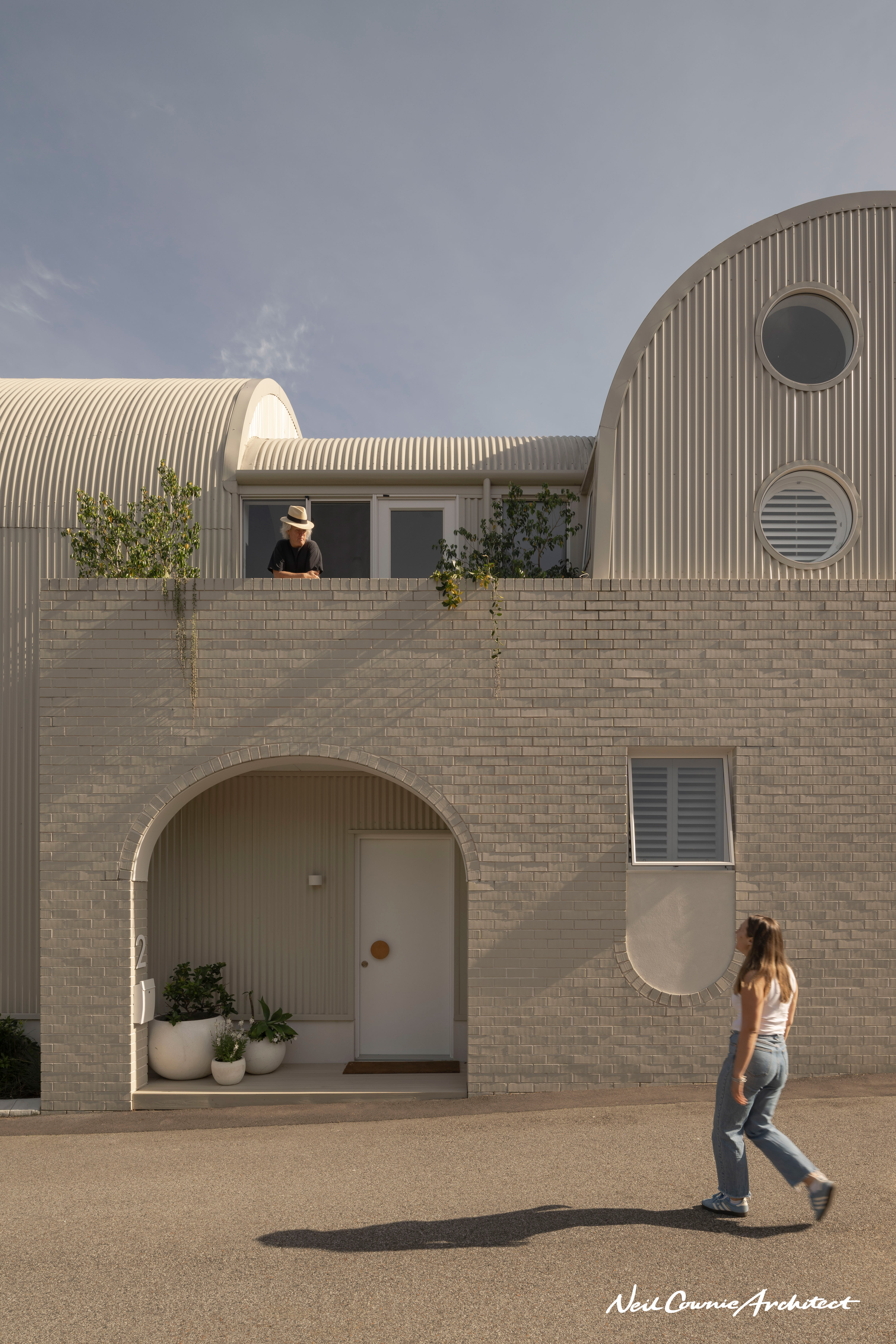
The design of the new house takes cues from the more substantial remaining two-story townhouses within the sub-division with face brick walls and featuring arches to openings. The vaulted roof forms are a response to height limitations that allowed the project to maximise the height at which the building is habitable.
The compact building maximises the use of the site over two floors through split-levels and a roof terrace. The timber framed walls and timber suspended floor building delivers on its sustainable credentials which are further enhanced through the passive solar design and careful provision of cross ventilation. A roof terrace at the top of the house provides for both covered outdoor entertaining and uncovered, with excellent views to the trees of Galbamaanup. A water wise garden has been designed with plants selected from the adjacent wetland. Storm water from the building is collected at ground level ‘wetland’ garden swales.
SUSTAINABILITY
Except for the ground floor external walls, the remainder of the construction in the house is from timber framing and timber floor structure. The timber was specified for use in the house based on its sustainable credentials. On this small site, a north facing courtyard ensures space for deep soil tree planting. A first-floor balcony and the roof terrace give opportunity for further landscape planting.
The narrow nature of the design of the house allows for excellent cross ventilation.
Solar PV panels sit upon the curved roof and assist with the reduction in the need to use the energy from the grid.
Photographer & Video
Photographer - Dion Robeson.
Stylist - Anna Flanders.
Video - Ross Tinney


