Know Your Place
Yallingup
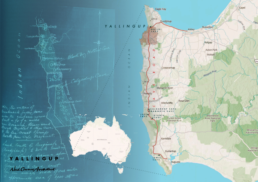
The name Yallingup is derived from the Noongar people’s place name which means ‘place of caves’, or ‘large hole’. The region of Yallingup takes in the main surf break at Yallingup reef, Rabbit Hill and further afield at the surf breaks of Three Bears, Smiths Beach and Indjidup. A visit to Yallingup will take you along Caves Road, a road purpose built to allow tourists to visit the over 100 cave sites along its route.
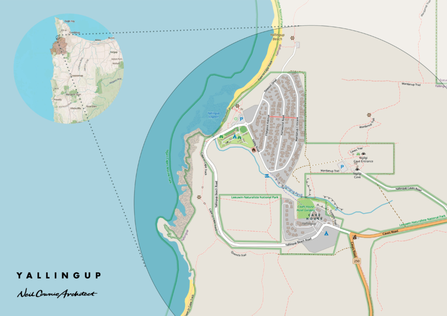
The following was sourced from the ‘Yallingup Brook Action Plan’: Aboriginal representatives identified the Yallingup Brook as a significant feature of their Dreaming heritage. One elderly Aboriginal representative reported the existence of an Aboriginal Sacred Site in the vicinity of Yallingup Brook. He described the site in relation to the legend of Ngiligi, the good spirit, and the bad spirit Wolgoine. Wolgoine lived in a dark hole (geedarluk), to which he would entice Nyungar people in search of drinking water, never to be seen again. Ngiligi heard of this and joined forces with the elements: sea (oderna), thunder (koondarnangoor), lightning (bal-bairn-chi) and wind (marr) to drive Wolgoine away. Together they drove Wolgoine back from the reef where he was watching the approaching storm. They forced Wolgoine up the mouth (dar) of the Brook and into his dark hole, all the while the storm increasing in strength.
They fought for many hours along the valley floor, which eventually fell in, closing the mouth of the Brook from the reef. Ngiligi beat Wolgoine at this location and the latter made his escape from the dark hole that had opened up during the fighting. Ngiligi told Wolgoine he must never return to the hole, and Wolgoine acknowledged that he was finally beaten. The Nyungar people were free from Wolgoine, the bad spirit. Sometimes you can hear the rumbling of the waves as they roll over the reef and up the valley floor, seeming to say to all Nyungar people “walk softly and listen to the call of ‘Ngitch-me’, the good spirit Ngiligi”.
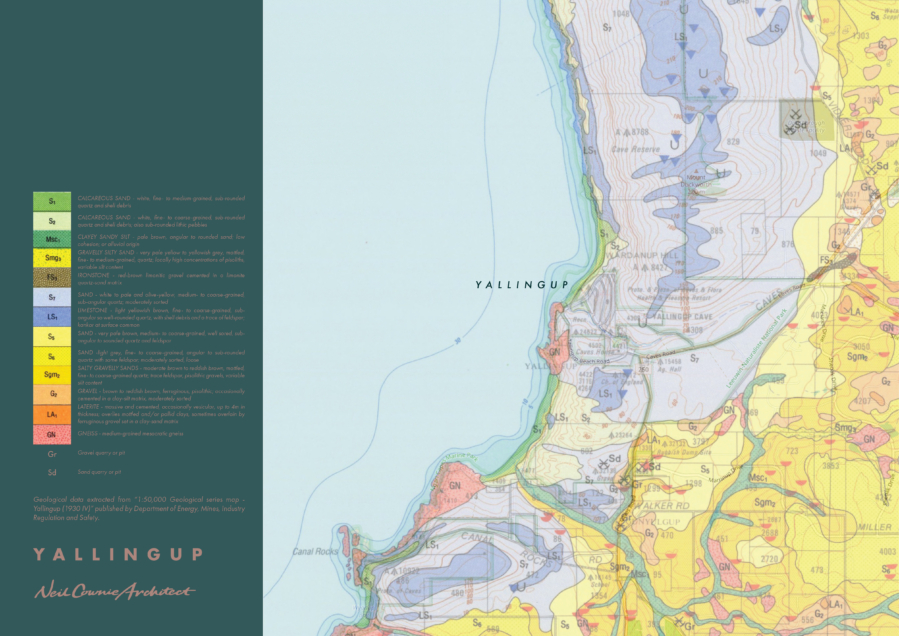
Dune limestones and caves are typical of the geology in the region around Yallingup. This type of geological make up is known as being of ‘Karst’ topography. With reference to the map ‘caves and karst of Australia by Webb & others (2003)’ as can be seen, the extent of the yellow area indicating the locations of ‘soft-rock Karst area’, the southwestern coastline of Western Australia is unique.
Karst is a topography formed from the dissolution of soluble carbonate rocks such as limestone and dolomite. It is characterized by features like poljes (large, flattened depression) above and drainage systems with sinkholes and caves underground.
Subterranean drainage may limit surface water, with few to no rivers or lakes. In regions where the dissolved bedrock is covered (perhaps by debris) or confined by one or more superimposed non-soluble rock strata, distinctive karst features may occur only at subsurface levels and can be totally missing above ground.
From the source: ‘The caves and karst of Australia by Webb & others (2003)’ forms the first chapter of the book Beneath the Surface: A Natural History of Australian Caves by Finlayson & Hamilton-Smith (2003).
The most distinctive group is the soft-rock karsts. These comprise the Tertiary marine limestones and Quaternary dune limestones of southern and western Australia (Jennings, 1968; Grimes, 2002, 2003). The climate is Mediterranean to sub-arid. They differ from the 'hard-rock' karsts not only in being poorly consolidated (soft), but also in having a pronounced primary matrix porosity. The lack of strength in the rock increases the likelihood of collapse modification of caves, but extensive systems are known (e.g. Old Homestead Cave, on the Nullarbor, has about 30 km of passage). Recharge is local and diffuse, with minor point inputs through dolines. Allogenic input from surface streams is locally important (e.g. in parts of Western Australia).
The Quaternary dune limestones are soft syngenetic karsts (Jennings, 1968; Grimes, 2002, 2003). They mostly form linear ridges parallel to the coast. See Bastian (1964, 1991, 2003a,b) and Williamson & Bell (1980) for West Australia; for southeastern Australia see White (1994, 2000) and Grimes & others (1999). Smaller areas occur on some of the islands of Bass Strait, and on Lord Howe Island.
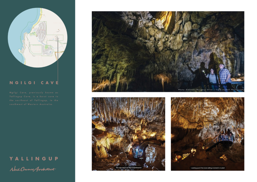
In September 1899, the Yallingup Cave was ‘discovered’ (by Europeans at least) by Edward Dawson, who notified the State Government of his find. The Cave was subsequently opened to the public, with Dawson as guide. The Cave is variously mentioned as the Cave or the Caves.
The tourist attraction of the caves in the Yallingup and Augusta-Margaret River area was well recognized from the outset, and the Government developed accommodation for visitors to them, with 'Burnside', 'Wallcliffe House', and Cave House all open by December 1904. The location of 'Burnside' and 'Wallcliffe House' was not given and no further information was available. The benefit of good roads from Busselton to Yallingup, and from Yallingup to Margaret River was recognized, and improvements were made in 1904, with the latter road nearing completion in late December. In May 1905, tenders were called for the construction of a billiard room and a tennis court at Yallingup Caves Accommodation House.
Within the depths of Yallingup’s Ngilgi Cave there is evidence of ancient animal fossils with the discovery of the tooth of a thylacing or Tasmanian tiger, the fossil of a seven-foot-six tall megafauna kangaroo and a wombat that was as big as a cow known as a Zygomaturus along with other marsupials.
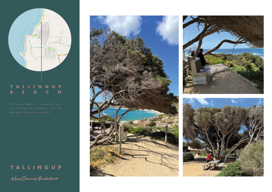
The wonderful windswept trees found along the Yallingup beach front are part of the Melaleuca lanceolata (otherwise known as Rottnest TI-trees) forest along the Leeuwin Naturaliste ridge. The area of Yallingup falls within the Ambergate Reserve of the City of Busselton. Ambergate Reserve is a 75-hectare area of remnant bushland representing the originally widespread shrub-land and woodland of the local area. The reserve holds significant conservation value, with three threatened ecological communities making up more than 80% of the reserve. At least 80 species of birds, including 10 species of water birds, and a range of native marsupials, reptiles, and insects persist within the reserve. (Source: City of Bunbury - ‘Keeping it Local’).
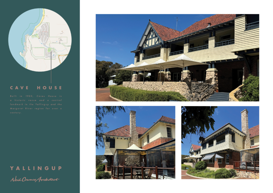
When you think of Yallingup you immediately think of Caves House which remains a much-loved place amongst the local community and visitors with the Inter-war Old English style building adding to the character and sense of history to the area of Yallingup. The place was first called Yallingup Cave Accommodation House, then Cave House Yallingup, and subsequently Caves House.
In early March 1902, the Government considered the building of an accommodation house to cater for visitors to Yallingup Cave, and the Caves Board discussed the matter. The estimated cost was £2,000 to erect and to furnish the accommodation house. The Board was divided over the issue of whether a license should be granted near Yallingup Cave, and also regarding the relative merits of a hotel or accommodation house being built by the Government or private enterprise. In January 1903, Caves Accommodation House, the first Caves House, was opened to the public.
On 4 December 1930, a fire caused extensive damage to 'the old wing of Cave House, Yallingup', estimated at £5,000. It was reported that 'a little more than half the wing comprising the basement, the store-rooms, the dining room, the hall and the staircase, two drawing rooms and six bedrooms' were 'totally destroyed. The new hotel (1938-39) was built by R. Donald & Son. Principal Government Architect A. E. Clare was responsible for the design of the new hotel. Clare was assisted by S. B. Cann, who later became Principal Architect. The new hotel (1938-39) is a very fine and substantial example of the Inter-War Old English style. The hotel became a popular location for newly-weds to honeymoon, as was the case with my own parents who had their honeymoon at Caves House in 1951. (Source: Inherit DPLH - Caves House).
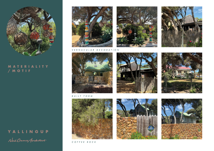
The housing on Yallingup Hill has long been a sought-after location to have a holiday house. I can remember when, probably in the early 1970’s, when there was more bushland on the hill than houses and the houses slotted nicely between the trees. The houses were generally of timber framed construction, set up above ground level on columns, allowing the steep fall of the hill below to continue to ‘do its thing’. These Yallingup Hill houses were generally quirky buildings that had a sense of character and fun. I remember Yallingup Hill as representing the character of the ‘down south’ region with the Surfside café being the only wind-blown location in the area to feed yourself after a surf and roughing it, probably sleeping in the back of the car on a ‘down south’ trip.
For me, the Yallingup area is steeped with history within my own lifetime, a place that I have visited and loved since a young age. Despite the more recent out of local character McMansions built upon Yallingup Hill, the area retains that special character that ensures that you know that you are experiencing a place that is very special. Many of the early buildings on Yallingup Hill still serve as excellent examples of the local character. These buildings are of a small-scale ort are articulated into several small components. Buildings are integrated with the existing trees and in some cases the roofs of the buildings do not exceed the height of the tree canopy.
The original contours of the hill across the site are maintained and the building hovers above the changes in level on columns.
One of the greatest losses for the township of Yallingup was the loss of the 'commercial diversity' of the small collection of shops along the edge of the carpark. Surfside general store complex (originally known as Hammond Tea Rooms built in the 1950's) had a relaxed casual mood appropriate for the location where you could buy most things, at least things that a young surfer would be in need of. The demolition of the of the Surfside buildings and their replacement with short stay accommodation was short sighted and was a detriment to the community.
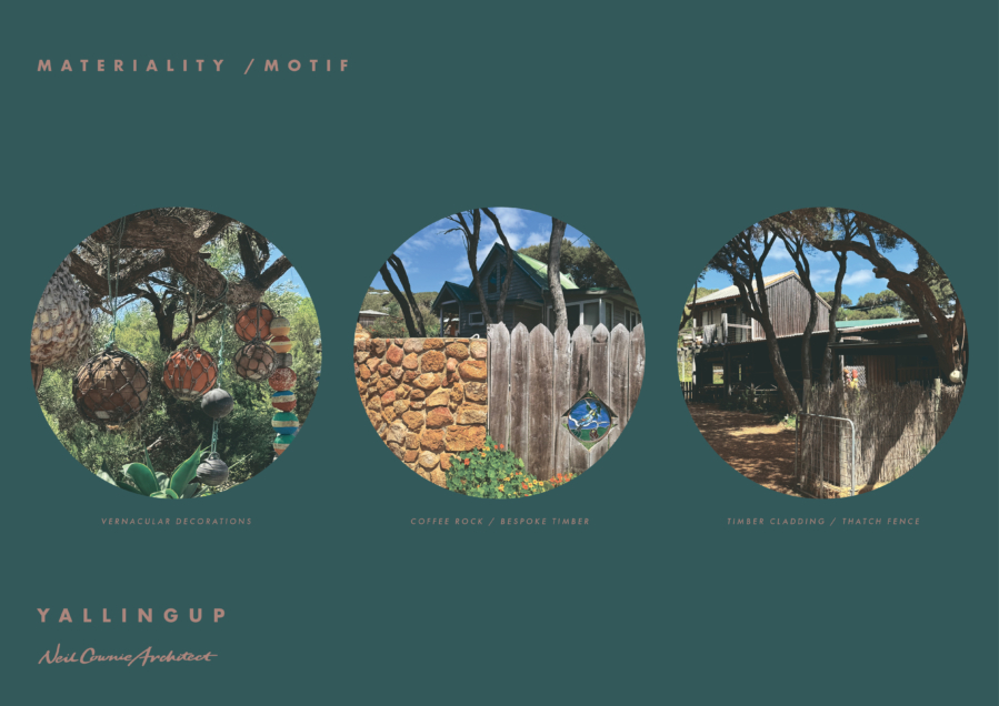
The materiality is of the place with coffee rock walling to external walls of buildings and to retaining walls sourced locally. The external timber cladding is allowed to grey and in doing so matches the bark colour of the existing trees.
Buildings are either very simple forms or in some cases experimental whereby determining that the occupants experience a different environment when on holiday from their suburban homes.
Generally, houses are without front fences with the exception being houses at the lowest point of the hill where vehicle traffic is at its heaviest and fences in coffee rock and bespoke timber designs provide unique character and rustic detail and texture.
Front gardens are embellished with local found objects from beach combing which have been turned into sculptural displays.
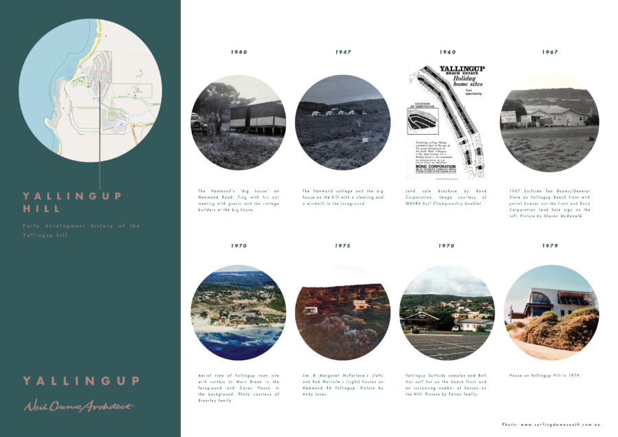
The ’Surfing Down South’ website and book are a great resource for record of our more recent heritage in the Yallingup area (and beyond). From ‘Surfing Down South’ (and the Hammond Family) – ‘ In 1933 Thomas Garfield Hammond purchased circa 100 acres of land at Yallingup in front of the historic Caves House Hotel site owned then by that state government.
Thomas built rental cottages and grew oats on the land. 66% of the Hammond land was developed and 34 % was left as undeveloped.
Thomas ‘Ting’ Hammond and his wife Silvia ‘Dorrie’ Doreen (nee Burkett) bought up their sons William ‘Garth’ and Graham ‘Jack’ on Yallingup hill. ‘Ting’ Hammond built their first family cottage on the undeveloped side of the valley in Yallingup in the 40s. Today only the remnants of the white cap rock chimney and a fruiting fig tree remain. His wife Dorrie used figs from the fig tree to make fig jam for tourists visiting Yallingup. Initially tourist buses visited the ‘big house’ for refreshments, then in the 50s the Hammond Tea Rooms (Surfside) were built on the beach front at Yallingup. The tea rooms served food, Devonshire teas and petrol.
Records show that circa 1952 to 1966 there were just the lower roads on Yallingup Hill. Then the development of Wardanup Crescent was undertaken by Alan Bond from Bond Corp and sold in and around the 1967 to 1972 era. Interestingly Wardanup Crescent is named after the Wardanup Ridge which is visible behind the Yallingup Hill town site, which is a name from the Wardani people, of the Noongar nation.
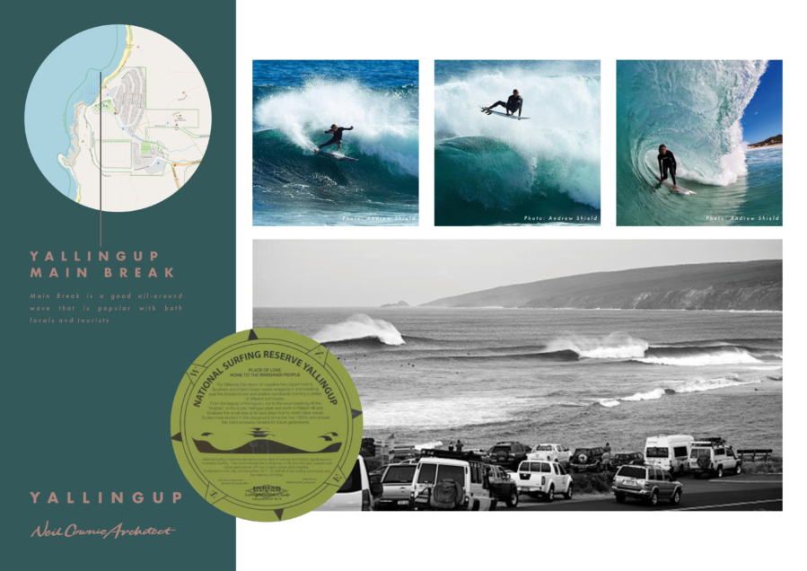
You cant talk about Yallingup and not include talk of the surf. The surf breaks of Yallingup main break, Rabbiits, Smiths Beach, Super Tubes, Three Bears and Indijup offer a diversity with swell size and wind to ensure there is usually somewhere working.
The first surf shop in the Cape Naturalist region was opened in 1971 when Californian ex-pat Tom Hoye (who passed away in 2012 at age 74) arrived in the South West with his family and opened the first surfboard shop in the Lurch Cottage next to Surfside Store Yallingup.
Many surfers originating from Yallingup have been successful in international competition with those including Melanie Redman-Carr, Claire Bevilacqua, Jake Paterson, Paul Paterson and Taj Burrow.


